The Lakeside Trail Project connects existing multi-purpose trails through the urban core of Tahoe City, along the lake shore. The project involves roughly one mile of trail and includes amenities such as plazas, landscaping and interpretive signage.
The phases represented logical segments of trail based on ownership, easements, or other constraints. Beginning with Phase I, a completely separated trail with access to the shoreline of Lake Tahoe and the Truckee River was the primary vision. Numerous regulatory issues and opportunities resulted from that vision. Since the EIR was completed in 1998, AEC has been the prime consultant involved in the preparation of plans and specifications for the construction of the first phases of the project. By the time it was completed, the Lakeside Trail represented over $25M in construction, planning, engineering and land surveying.
PHASE I-II
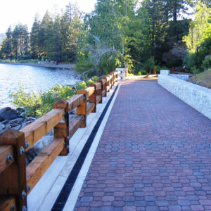
Phases IA and IB of the trail were constructed in 2002 and 2003 respectively. Phase IA consisted of a predominately 10 foot wide, 700 foot long paved path with two foot vegetated shoulders on both sides. The design incorporated river overlooks that afford maximum views, quiet riverfront settings and are alongside the existing wetland areas to educate users about the origin and history of this unique vegetative community, erosion control and water quality enhancement techniques. The other interpretive sites focused on an existing weather station and stream gage to educate users about river and lake level management. Additionally, signage contains design elements that incorporate the importance of the historic railroad uses at the site.
Features associated with the Lakeside Trail,
Phase IA segment included:
Handicap Accessible Boat Launch
Boat Staging Area
Two Roundabouts
River Overlook
Two Wetland Overlooks
Weather Station Interpretative Station
Picnic Area
Phase IIA
Outlet Crossing Alignment was completed in 2008. This project supplied the missing link which provides for pedestrian safety and improved traffic circulation. The Outlet Crossing connects the existing Truckee River Trail on the east side of the Tahoe City Bridge at State Route 89, and proceeds through the southern State Parks parcel where the Gatekeepers Museum is located then extends across the Tahoe City Dam and terminates on the northern State Parks parcel, near Mackinaw Road/State Route 89. The existing utilities located inside the dam structure and the water line located underneath the Tahoe City Bridge were relocated underneath the new dam crossing, improving dam operations.
As a community resource, the alignment provides convenient access to the natural beauty of Lake Tahoe and its shoreline. View corridors were emphasized, and historical features were incorporated into the design. Interpretive exhibits illustrating the dam history and operations were placed along the trail. The Outlet Crossing Alignment provides users an enjoyable, pedestrian friendly environment that showcases Lake Tahoe, the Truckee River, the Tahoe City Bridge, and the Tahoe City Dam.
PHASE III
The Lakeside Trail Phase III segment consists of a 10 foot wide, 800 foot long paved path across the Commons Beach and Watson Cabin parcels. The trail is accessible to both bicyclists and pedestrians, and offers opportunities for wintertime uses, such as cross-country skiing. Commons Beach is a 6.9-acre public beach area that has a tot-lot, picnic table, swimming access, and parking. Design of this project coincided with the Commons Beach Enhancement Plan proposed by TCPUD. The Enhancement Plan included appropriate connections with the proposed Lakeside Trail Phase III, slope stabilization, shoreline stabilization, lake overlooks, child play areas, expanded sand area, a new restroom, enhanced beach access, enhanced picnic and seating areas, and extensive landscaping and revegetation. To protect the lake from erosion and storm water runoff, but more specifically to stabilize proposed ground disturbing activities as a result of trail construction, native landscaping was used directly adjacent to the trail. The trail intersects the existing parking lot and restroom facility allowing users easy access to these amenities.
The Lakeside Trail Phase III
Commons Beach provides users access to the following features at Commons Beach:
Views of Lake Tahoe
Existing restroom facilities
Picnic areas
Parking lot
Beach
Architectural resources including the Tahoe City Community Center and the historical Watson Cabin
PHASE IV
The proposed Lakeside Trail Phase IV segment is approximately 615 linear feet and begins at the base of the stairway from Highway 28 to Commons Beach where design included interlocking pavers and widening to facilitate this safe transition Commons Beach, and terminates at a connection to Grove Street in Tahoe City. This trail segment includes a 2′ shoulder on both sides of the trail and an infiltration trench along the uphill side of the trail. This trench provides for the transport and infiltration of stormwater runoff to the proposed treatment area located underneath the boardwalk area. This trail segment also proposes a safety pullout and interpretive area for Swallows Bank consisting of pavers, a stone seatwall and interpretive panels. This segment will be a “walk bike” area due to safety and congestion concerns.
Much of the trail alignment is located within the Backshore zone. Bank stabilization and restoration was required along Lake Tahoe. Revegetation of the area was extensive due to existing and proposed disturbance.
Landscaping along both sides of the trail was done to screen the trail from the lake and to restore areas of disturbance.
Phase IV provides the following features:
A connection to Grove Street from the terminus of the Phase III trail at Commons Beach.
Filtered views of Lake Tahoe.
Access to downtown commercial areas including shopping and restaurants.
Historical interpretation of the two historical sites known as Swallow’s Bank Washoe Site and Lake Tahoe Railway and Transportation
Company Linear Site.
Access to Phase III Commons Beach that includes restroom facilities, picnic areas, parking lot access, and beach access.
Bank stabilization, restoration, and revegetation.
Clustered plantings in select areas along the trail.
A safety pullout and interpretive area located along the boardwalk provide trails users filtered views of Lake Tahoe to the East and views of Swallows Bank and Swallows Cliff to the West.
Stabilization and revegetation of the eroding bank enhance the shoreline as viewed from Lake Tahoe.
Revegetation of a portion of Christy Hill enhance the view of that area from Lake Tahoe.
Trash removal involving heavy scrap metal has enhanced the scenic integrity of the area.
PHASE V-VII
The Lakeside Trail Phase V-VII projects, proposed by the Tahoe City Public Utility District (TCPUD), are the most recent segments of the continuous trail route, between the North Shore, West Shore and Truckee River trails providing a Community Trail Intertie that culminates at the entry of Tahoe City, CA. The trail provides increased safety to traffic and trail users since these conflicting uses are physically separated. As a community resource, the trail provides convenient access to the natural beauty of Lake Tahoe.
The Project will provide the community and its visitors the following features:
A pedestrian connection from Grove Street and a connection to the terminus of the Phase IV trail.
Filtered and unfiltered views of Lake Tahoe.
Pedestrian and bike access to downtown commercial areas including shopping and restaurants.
Access to and from the Tahoe State Recreation Area and Pier.
Urban improvements to the northern entrance to Tahoe City.
Historical interpretation.
Bank stabilization, restoration, and revegetation.
Wetland restoration and improvements.
Temporary and permanent BMP features to protect water quality.
Services Provided by AEC incorporated nearly all civil, land surveying and regulatory permitting consulting services required for the project which included:
Public Communication/Facilitation
Environmental Impact Report
Entitlement processing
CEQA,NEPA Compliance Report
Boundary and Topographic Surveys
Civil design and cost estimating
Construction Staking
Utility Relocation Coordination
Interpretive Facility Planning and Design
SWMM Drainage Report
Submittal Review and Construction Observation/Management
Waste Discharge Requirements (WDRs)
SWPPP Monitoring
Project Administration-Revise/update SWPPP, NOI, Site Plans – SMARTS Upload
Pre-Construction Contractor Training
BMP Install Observation
Visual Site Inspections and Reporting
Pre-Post Rain Event Inspections
Tailgate SWPPP Training
Prepare REAPS
Stormwater Sampling, Analysis and Reporting
Prepare Annual Report
All documentation available electronically for inclusion into onsite SWPPP.
The Phase IV segment contains a raised boardwalk through wetlands and includes close proximity to shoreline. AEC provided all permitting, engineering, surveying, and construction services for all segments. Coordination with multiple public agencies was required including TRPA, Lahontan Regional Water Quality Control Board, California Department of Fish and Game, United States Army Corps of Engineers, California Tahoe Conservancy, United States Bureau of Reclamation, various utility companies, and California State Parks.
Date of completion: 2012
The Lakeside Trail is a one-mile segment in the largest paved trail system at Lake Tahoe, connecting the North Shore, West Shore, and the Truckee River and Squaw Valley. This segment courses through the core of Tahoe City in close proximity to the Truckee River and Lake Tahoe and was developed in seven phases due to its complexities. Water quality and coverage mitigation strategies were successfully implemented throughout the trail and allowed for enhanced restoration of areas that had been previously disturbed. Managed public access and friendly barrier features have kept users on the trail and away from sensitive areas. Major utility upgrades and relocations as well as storm water treatment facilities and source control measures on and off site were key benefits of the trail.